T
Great question, but I know for sure this is the longest tunnel I have ever been trying to get through. 2020 is a year we will all remember and at the same time, want to forget. It reminds me of something that went horribly wrong in the past and someone ALWAYS brings up the incident when you see them--particularly family members. It is just too strange and painful to keep buried.
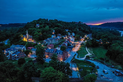
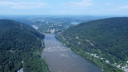
My racing season has gone up in smoke and may not return until next summer. I have been struggling to get any real training done and the only outlet has been some hiking in the area. Harpers Ferry had been referred to prior to the Civil War as "The Hole". Not a nice moniker, but it is really accurate. The river beds in HF are around 220 foot of elevation and we live at 500 feet on top of the hill in town. If you cross either river, you have a mountain to scale. The Maryland side has a 1442 foot peak and the Virginia side has a 1138 foot peak within an hour hike of our house. I have been exploring the hiking trails, there are many and most are well trod. The hiking has been a great way to get in some aerobic work, take some great photos of the town and also get stronger in the process. The warm weather makes it a challenge, I have really made a lot of heat on these jaunts and soaked a lot of clothing. Fall weather should make these treks less demanding.
 |
| Harpers Ferry lower town |
 |
| The Hole |
Since the hiking has been a way to get some conditioning, I have signed up for a "Climb Everest Challenge" which is a 50 day event and during that time you need to climb the equivalent height of Mt Everest, which is 29028 feet.I have done several climbs that take about 2 hours and yield about a 1500 foot elevation change. So this should be something I can do. Of course, you need to stay healthy and not get hurt just like track and field...... The modern day maps and elevation devices that are available on our phones are a huge part of getting this challenge done. The elevation changes can be calculated accurately and quickly. I will be using an Excel spreadsheet to track the progress and that will be my nerd out moments. We will see how this goes.
I have also signed up for another virtual event, the Pittsburgh Steelers are running their 5K virtually this year and I have talked my daughter and neighbor lady into running it with me. We should be able to run it late next week on a day with few tourist in the area. During the weekends and summer months, the HF area is a hotbed of bikes, hikers and kayakers and it is tough to get around and keep a safe distance situation in place.
The old C & O Canal tow path will be our venue, is a hard packed with a very smooths surface that is about 10 feet wide and also conveniently still has mile posts intact. The elevation change on this trail is about 15 feet from mile 59 to 61. So we will have a very flat smooth surface with a lot of shade to do our 5K event right along the Potomac River. This section of the river has about 30 feet change in elevation and the rapids provide a soothing sound through this region. I cannot think of a better area to do a 5K. My daughter does several 5Ks per year, the neighbor lady is training for a half marathon this Fall and I am always trying to break 30 minutes. I think it should be a fun and entertaining event. Stay tuned for results.
Comments
Post a Comment